Watch Six Months of Fracking Fires Blaze Across the Country
Massive fires light up the sky in U.S. states at the center of a fracking boom.
The fires — known as flaring — are a symptom of the rapid spread of the controversial drilling technique. Cities and towns across the country are scrambling to keep up with a newfound surplus of natural gas, and towering flames arise when excess gas is burned off at drill sites.
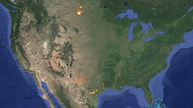
Now, one environmentally minded organization has created a tool to track where the fires are taking place. The heat map below — created by the nonprofit SkyTruth — shows a time-lapse of flaring across the U.S. over a six-month period from March to August.
{{thirdPartyEmbed type:animatedgif source: http://assets.nationaljournal.com/gfx/Fracking_ss.gif}}
Most of the flaring on U.S. soil currently takes place in North Dakota and Texas due to oil and gas drilling operations in the Bakken and Eagle Ford shale formations, respectively. Widespread flaring also crops up in Pennsylvania, where energy companies extract a huge amount of natural gas from the Marcellus Shale.
Fossil fuel producers say flaring is nearly impossible to avoid, because the infrastructure needed to transport gas and oil is severely lacking in many states so they are forced to burn off the overflow. But green groups warn that the fires release greenhouse gases and waste energy.
According to a report by environmental advocacy group Earthworks released Friday, flaring has dramatically increased in both the Bakken and Eagle Ford shale in recent years.
"In 2010, oil and natural gas wells in the Bakken flared about 18 billion cubic feet of gas. In 2013, they flared 96 billion cubic feet, almost all of it from oil wells," the report states.
Texas, meanwhile, flared 2 billion cubic feet of gas from oil and natural-gas wells in the Eagle Ford in 2010. In 2013, 34 billion cubic feet of gas had been flared.
For the sake of context: "The amount of gas flared is so large, especially in the Bakken, that it compares favorably with the volume of gas produced for use from shale gas formations in other states," the authors note.
SkyTruth created the visualization using satellite data collected by the National Oceanic and Atmospheric Administration. The GIF above advances in 10-day intervals starting on March 17 and ending on Aug. 20, using 29-day composite data from detected flares.
To view the map with real-time updates and see flaring in both the U.S. and the rest of the world, click here.